


Now Reading: Mumbai Coastlines To Get Smart Flood Sensors As Climate Risk Rises In Indian Cities
-
01
Mumbai Coastlines To Get Smart Flood Sensors As Climate Risk Rises In Indian Cities
Mumbai Coastlines To Get Smart Flood Sensors As Climate Risk Rises In Indian Cities
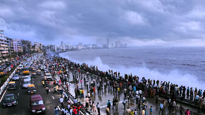
Mumbai will soon install smart flood sensors across vulnerable coastal stretches, placing the main keyword Mumbai smart flood sensors at the forefront of India’s climate adaptation strategy. As extreme rainfall, tidal surges and sea level rise intensify, urban planners are turning to real time digital monitoring to protect high density populations.
India’s coastal cities are experiencing more frequent climate shocks. Mumbai, with its mix of ageing drainage systems and expanding construction, faces recurring floods during monsoon peaks. The new sensor network aims to provide early warnings, faster data-driven responses and improved coordination among disaster management teams.
Why Mumbai needs a smart flood sensor network now
Mumbai’s geography makes it naturally vulnerable. Much of the city lies near or below sea level, with narrow drainage pathways, reclaimed land, and high tide interactions that amplify flooding during heavy rain. Over the past decade the city has seen multiple extreme rainfall events that brought public transport, business districts and residential neighbourhoods to a standstill.
Smart flood sensors offer a modern solution to an old challenge. They provide continuous data on water levels, tidal behaviour, rainfall intensity and ground saturation. Unlike manual monitoring, sensors deliver alerts in real time to control rooms, allowing authorities to take quicker decisions such as diverting traffic, activating pumps and closing vulnerable underpasses.
The network will also enable predictive modelling by combining weather inputs with local water-level readings, helping anticipate flash floods before they escalate.
How the sensor system works and what it will monitor
The sensors will be installed along key coastlines, river outlets, storm water drains and traditionally flood prone pockets. Each device will track parameters like rising water levels, drain flow speed, soil moisture, high tide peaks and sudden surges from backflow.
Data will be transmitted to central dashboards accessed by the municipal corporation, disaster response units and meteorological teams. The real time flow of information helps authorities identify hotspots even before visible flooding occurs.
The system will integrate with existing city infrastructure such as pump stations, emergency helplines and traffic management systems. If a sensor detects rapid water rise at a coastal point, automated alerts can trigger actions like pump activation or alerts to emergency crews. This interconnected approach reduces manual delays and improves response coordination across departments.
Urban climate risk rising across Indian cities
Mumbai’s move reflects a wider trend. Climate related risks have escalated across Indian urban centres including Chennai, Kolkata, Kochi and Visakhapatnam. Rising sea levels, more intense cyclones, urban heat islands and unpredictable rainfall patterns are putting stress on drainage and infrastructure networks.
Many cities have already faced economic losses due to flooding, ranging from property damage and business disruptions to health impacts and displacement of vulnerable communities. Mumbai’s frequent monsoon flooding, particularly in low-lying areas like Kurla, Sion, Andheri and parts of South Mumbai, highlights the need for early intervention.
Smart urban adaptation tools such as sensor networks, advanced flood modelling, and integrated command centres are becoming essential components of city resilience planning. Mumbai is among the few Indian metros scaling these tools to a wider coastline-level deployment.
How residents and businesses will benefit from early warnings
Real time sensor data can improve public safety significantly. Early flood alerts allow residents to avoid vulnerable roads, protect vehicles, adjust travel plans and secure essential items. Public transport networks can suspend specific routes before waterlogging becomes severe.
For businesses, especially in districts like Lower Parel, BKC and Fort, timely warnings help shift operations, manage inventory at ground level and ensure employee safety. Hospitals and emergency service providers can increase preparedness when sensors indicate potential water rise along access routes.
In the long term, sensor data can guide infrastructure planning by identifying chronic problem zones. This supports better drainage redesign, pump placement, embankment reinforcement and zoning decisions.
Challenges ahead as Mumbai implements the network
Despite its potential, the system must overcome operational and maintenance challenges. Sensors exposed to saline conditions and monsoon winds require regular calibration and upkeep. Connectivity issues may arise during storms, necessitating backup communication channels.
Authorities also need trained personnel to interpret data accurately and coordinate responses quickly. Technology alone cannot solve Mumbai’s flooding problem; it must align with broader drainage upgrades, coastal protection projects and urban planning reforms.
The success of the initiative will depend on how well data insights are integrated into real time decision making and long term infrastructure investment.
Takeaways
- Mumbai will install a wide network of smart flood sensors to improve early warnings along vulnerable coastline and drainage points.
- Rising climate risks and recurring monsoon flooding make real time monitoring critical for public safety and infrastructure resilience.
- Sensor data will support faster emergency response, predictive flood modelling and long term planning for drainage upgrades.
- Successful implementation requires robust maintenance, skilled teams and integration with broader urban climate adaptation measures.
FAQs
Q: What will the smart flood sensors in Mumbai monitor?
A: They will track water levels, tide surges, drain flow speed, soil moisture and rising flood patterns across coastal and low lying areas.
Q: How will the system help residents during heavy rains?
A: Early alerts will allow people to avoid flooded stretches, adjust travel and receive warnings before water levels become dangerous.
Q: Will the sensors alone solve Mumbai’s flooding issues?
A: No. They provide essential data and warnings but must work alongside drainage improvements, pump upgrades and coastal protection measures.
Q: Which city departments will use the sensor data?
A: Municipal control rooms, disaster response teams, traffic management cells and weather monitoring units will all access the live data.